
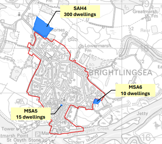
Tendring District Council’s (TDC) consultation on the Local Plan continues until 23rd March. The plan proposes 325 new homes for Brightlingsea, primarily through Site SAH4 (Land East of Church Road, on Samson’s Road opposite the old church, see map).
The Council justifies this by claiming Brightlingsea “benefits from a range of existing infrastructure and facilities”:
…and Brightlingsea have large populations in comparison to rural settlements and benefit from a range of existing infrastructure and facilities. These settlements provide a range of opportunities for the use of public transport, walking and cycling and because they have established town centres, employment areas and infrastructure, they provide locations where, with the right action, it is possible to create a significant number of additional new jobs and deliver sustainable housing growth on a large scale.
3.55 Local Plan – Preferred Options Consultation Document (Reg18)
SAH4 is a residential allocation only. No employment land is allocated alongside it. In the absence of new local employment sites, additional residents would likely commute. That increases traffic rather than reducing it.
Taken together, both the lived experience of residents and the technical evidence tell a different story. If you are writing a consultation response, below are some points you might want to think about including if you need inspiration, along with the sources, like the above.
For the sake of transparency and detail, I have uploaded and linked to (at the bottom) all of the response I have received from the FOI/EIR request about traffic etc. for Brightlingsea and Thorrington.
1. Thorrington Cross: A Junction at 219% Capacity Already
Every car leaving Brightlingsea must pass through the Thorrington Cross mini-roundabouts (Junction 16). The Council’s official modelling (the North Essex Model) confirms this junction is a disaster:
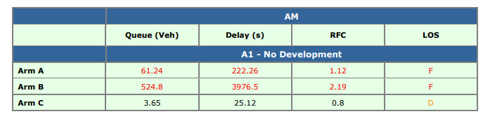
- Existing Failure: Even without any new Local Plan homes, the junction is modelled at a Ratio of Flow to Capacity (RFC) of 2.19 in the AM peak. An RFC of 1.0 is the physical limit. This junction is already operating at 219% of its intended capacity.
- The Planned Reality: With growth, this fails further to an RFC of 2.61.
- The “Cautionary” Corridor: The B1027 route from Brightlingsea to St Osyth is officially RAG-rated as “Cautionary” (!) due to projected speed reductions and increased queuing upstream on Brightlingsea Road.
- Bear in mind, this work was done in 2015 and since then there has been lots of development in and around Brightlingsea, and we are yet to feel the pressures of the Robinson Road development.
All of this is from two reports:
Tendring Local Plan Modelling Support Highways 10/12/15 EB8.1.3 is a December 2015 transport modeling report titled “Tendring Local Plan Modelling Support,” prepared by Jacobs for Essex County Council (ECC) to assist Tendring District Council (TDC) with this Local Plan.
Preferred Options Local Plan Transport Evidence – Assessment Case is a document provided to me via one of my FOI requests.
2. The “Infrastructure Gap”: No Plan, No Budget
The most damning evidence is found in the Jacobs Stage 3 Modelling Support report. While the Council identified 16 junctions across Tendring that need urgent mitigation, Thorrington Cross was excluded from the priority list for design and costing.
While other villages like Frating and Elmstead Market have mitigation schemes costing between £1m and £3m identified in the plan, there is zero identified spend to fix the Thorrington bottleneck. Despite Policy DI1 stating that development “must be supported by… infrastructure capacity,” the Council has provided no engineering solution for the town’s only exit point.
Significant junction upgrades of this nature typically require capital funding in the millions of pounds. No such costed and funded scheme is currently identified for Thorrington Cross.
3. The “Sustainable Travel” Myth
The Council’s transport model assumes that “sustainable travel reductions” (people switching to walking, cycling, or buses) will remove 120 car trips from the B1027 in the AM peak. However:
- No Paths: The reports admit that the Thorrington Cross junction has “narrow footpaths” and physical constraints (like the war memorial) that make improvements for pedestrians “difficult”.
- Safety Failure: Local Plan Policy LP6 (see below) defines a route as “safely accessible” only if it has “dedicated pedestrian infrastructure” away from traffic hazards. Currently, no continuous, safe cycle or pedestrian path exists between Brightlingsea and the B1027 corridor. And currently, through our work with the Sunshine Coast Greenway, Essex County Council does not see any chance of a safe, segregated cycle path out of Brightlingsea avoiding Tenpenny Hill.
- AM Peak Failure: The 2026 Assessment Case admits that while sustainable travel helps in the PM, “problems remain in the AM peak”.
All new dwellings on such developments must meet one or more of the following locational criteria:
- Be safely accessible on foot within 600 metres of the edge of the settlement development boundary of one of the District’s ‘strategic urban settlements’ or ‘smaller urban settlements’;
- Be safely accessible on foot within 400 metres of the edge of the settlement development boundary of one of the District’s ‘rural service centres’;
- be located directly adjacent to the development boundary of a smaller rural settlement. In all cases, the site must be safely accessible on foot from the nearest settlement boundary.
- form at least half of the market homes being proposed as part of a rural exception scheme in line with Policy LP6; or
- Involve the redevelopment of vacant or redundant previously developed land that can be demonstrated, with robust evidence, to be unviable for current and/or future employment use.
4. Cumulative Stress: We Aren’t Growing Alone
The pressure on our GP surgery (serving Brightlingsea, Thorrington, and parts of Alresford) and roads isn’t just coming from SAH4. The Local Plan also proposes:
- Hare Green Garden Village: 4,500 homes (Frating area).
- Alresford: 140 new homes (SAH6 and MSA7).
- Thorrington: 60 new homes at Avocet Place (MSA23).
Strategic Policy DI1 requires the Council to consider the “cumulative impact of development”. Growing all these settlements simultaneously without a combined infrastructure upgrade plan is a recipe for service collapse.
5. The “Buffer” Argument: SAH4 is Not Necessary
TDC is currently proposing far more housing than the government requires:
- Mandatory Target: 18,071 homes.
- Proposed Supply: 19,517 homes.
- The Surplus: TDC has a “flexibility buffer” of 1,446 homes.
Removing the 300 homes at SAH4 would not stop the Council from meeting its legal targets. It would simply bring the plan closer to the actual requirement while protecting a town that has reached its “practical limits” for growth.
6. The Sustainability Test: Real World Travel, Not Theoretical Maps
National planning policy and CIHT guidance require new development to be located in sustainable locations. That means realistic access to employment, education and services by walking, cycling and public transport.
On paper, Brightlingsea is sometimes described as having sustainable connections. In practice, the picture is very different.
Brightlingsea does not have a railway station. To access rail services, residents must first travel to Great Bentley, Alresford, Wivenhoe or Colchester by car or bus.
The bus network is limited. The 87 service runs roughly 2 to 3 times per hour. The new 78 service provides a direct connection to Great Bentley station, but only every other hour. Government and CIHT guidance generally consider a service to be “frequent” if it operates at least every 12 minutes. Brightlingsea is nowhere near that threshold.
Using live Google journey times at peak hour illustrates the point:
• Brightlingsea to Colchester at 8:00am
– By car: approximately 26 to 55 minutes depending on traffic
– By bus: significantly longer, up to 1hr 10min on a usual day without issues
– By cycle: over 1 hour, with no continuous segregated infrastructure and including the terrifying Tenpenny Hill
Cycling routes to and from the town must pass through Thorrington Cross and along busy stretches of road with 60mph speed limits and no segregation. There is no protected cycle corridor linking Brightlingsea to employment centresm, even within Brightlingsea itself.
A simple test is this: would most parents consider it safe for an 11 year old to cycle independently from Alresford, Frating or St Osyth to the Colne School via Thorrington Cross and Tenpenny Hill? The answer is self evident, which is why the only secondary school journeys not done by car or bus are from within Brightlingsea.
All new developments are expected to be within 400m walking distance of a bus stop measured along real pedestrian routes, not straight line distances. The existing bus stops near Samsons Road and Church Road Business Centre are currently very basic in form. Previous developments in the town have had to contribute funds to upgrade bus infrastructure. There is nothing in this plan to suggest this is on the table here.
The Local Plan also references strategic active travel ambitions such as the Sunshine Coast Greenway, which is a fantastic idea and concept, but this conflicts with ECC’s view of it currently. However, if ECC agreed that the SCG could be delivered then this would change a lot of the sustainability aspects of this development.
But as it stands, there is currently no committed, funded and deliverable segregated corridor between Brightlingsea and Thorrington, nor from SAH4 to Brightlingsea High Street or sea front.
Without a guaranteed package of active travel infrastructure and genuinely frequent public transport, the SAH4 allocation would increase car dependency significantly rather than reduce it.
That raises legitimate questions about whether the site can be described as sustainably located under national planning policy tests.
Contradiction
The inclusion of SAH4 contradicts the Plan’s own rules:
- Policy CP2: States permission will not be granted if the residual cumulative impact on the road network would be “severe”.
- Policy DI1: Requires “sufficient appropriate infrastructure capacity” before building.
Our Argument: Because Thorrington Cross is at 237% capacity and no mitigation is funded, the impact is mathematically “severe.” SAH4 cannot legally meet the requirements of Policy CP2 or SPL1 and should be removed from the plan now.
Policy CP2: Proposals will not be granted planning permission if there would be an unacceptable impact on highway safety, or the residual cumulative impact on the road network would be severe.
When granting planning permission for new development, the Council will require, through planning conditions or approved Construction Management Plans, that developers repair any damage to the public highway or public realm caused during construction and restore it to a condition equal to or better than its pre-commencement state.
Policy DI1: 10.13 Policy DI1 below sets out generic infrastructure requirements for new development within the District.
Strategic Policy DI1Comment
INFRASTRUCTURE DELIVERY AND IMPACT MITIGATION
All new development should be supported by, and have good access to, all necessary infrastructure. Permission will only be granted if it can be demonstrated that there is sufficient appropriate infrastructure capacity to support the development or that such capacity will be delivered by the proposal. It must further be demonstrated that such capacity, as is required, will prove sustainable over time both in physical and financial terms. Where a development proposal requires additional infrastructure capacity to be deemed acceptable, mitigation measures must be agreed with the Local Planning Authority and the appropriate infrastructure provider. Such measures may include (not exclusively)…
📢 HAVE YOUR SAY BEFORE 23 MARCH 2026! Submit your comments at: https://tendringdc.oc2.uk
Sources Referenced:
- TDC Local Plan Preferred Options Consultation Document (Reg 18)
- North Essex Model (NEMo) Transport Evidence – Assessment Case (Jan 2026)
- Jacobs Stage 3 Modelling Support (EB8.1.1)
- ECC EIR Response regarding Thorrington Cross (Jan 2026)
- https://matcourt.org.uk/wp-content/uploads/2026/03/23.2.26-7_20260119_TendringLP_Reg18_RefCase_FINAL.pdf
- https://matcourt.org.uk/wp-content/uploads/2026/03/23.2.26-4_Tendring-LP-Report-SHLAA-revisions-v4-for-foi.pdf
- https://matcourt.org.uk/wp-content/uploads/2026/03/23.2.26-5_Appendix-B-Link-Validation_v4.pdf
- https://matcourt.org.uk/wp-content/uploads/2026/03/23.2.26-5_Appendix-C-Journey-Time-Validation_v4.pdf
- https://matcourt.org.uk/wp-content/uploads/2026/03/23.2.26-5_Appendix-D-Bus-Route-Validation.pdf
- https://matcourt.org.uk/wp-content/uploads/2026/03/23.2.26-5_North-Essex-Model-2023-Validation-Technical-Note-Final.pdf
- https://matcourt.org.uk/wp-content/uploads/2026/03/23.2.26-6_20260119_TendringLP_Reg18_AssessmentCase_FINAL-1.pdf
4 replies on “SAH4 and why I think it needs to be removed”
This just proves everything that the local community is saying. The road system in Brightlingsea and Thorrington cannot cope with the current levels of traffic coming in and out of Brightlingsea. The road surface is not fit for purpose and in heavy rain is downright dangerous. Adding another 600 plus vehicles will make thing worse. There is no safe cycle way or even decent paths for pedestrians. The fact you have to cross the road at Gatehouse farm to get from one footpath to the other is also a safety issue as its on a hill and a corner.
Add to this the lack of infrastructure in Brightlingsea, namely doctors, dentist, and schools just means more traffic going in and out.
Brightlingsea has no rail links and a bus to Colchester 2 to 3 times an hour. No dedicated cycle way. No safe walking routes, and you have to come to the conclusion that these homes should not be built. We need the infrastructure and roads first. Then you can propose building houses, but not before.
Nicely summed up Andy. Any sensible & impartial assessment would agree that further house building on the suggested scale would be unacceptable.
I am sure that I have read that the Government’s recommendations for developments included the importance of them being close to rail travel connections and A road routes? Neither of which apply to Brightlingsea in general let alone this development in particular.
I understand also that the existing sewage/ waste/ storm water systems could be close to capacity.
Further, has a thought been given to the possibility of this development, one day, helping to
create an Upper and Lower Brightlingsea division/ split ? Them and us situations never end well for a community.
I don’t believe the infrastructure of Brightlingsea can support any further large developments in the town due to only one road in and out of the town. One doctor surgery, a couple of dentists. Schools that already can’t accommodate all the applicants from residents. This will ruin the town.